top of page
  • Writer: Walking With Brian
    Walking With Brian
  • Feb 19, 2023
  • 3 min read

Updated: Feb 20, 2023

Nestled in the Bathgate Hills, just beyond the historic town of Linlithgow, Beecraigs Country Park covers an area of 900 acres. I had driven by on a few previous occasions and today we mounted a mission to explore some of the walking trails within. The visitors centre has a café and a well-stocked gift shop. I bought a handful of postcards and we picked up a bunch of leaflets about other local attractions. Interesting how this type of promotional literature remains popular in an ever-increasing paperless society.


ree

A panoramic viewing window provided a sweeping outlook across the Forth estuary and an even better vista could be obtained from a raised platform beside the cattle barn. Half a dozen Highland calves were inside and we decided to head down to the field that contained the fully-grown beasts. The hardy Heilan' Coo withstands harsh windy environments with ease and the shaggy long-horned livestock has become a symbol of Scotland. As a child, I loved McCowan's Highland toffee. It featured a hairy bovine face on the packaging, although the confectionary was actually produced in Stenhousemuir, about 10 miles from where I stood, firmly within the lowland central belt. Another world-famous grazer - also present at Beecraigs - is the Belted Galloway, whose black coat is divided by a circular white band. As the name would suggest, this cattle breed originates from the southwest of Scotland. It has been exported all over the world and is known among American children as the Oreo-cookie cow, due to the colour scheme resembling the sandwich biscuit. I'm always up for a bit of cow spotting but I was about to find way more than I'd bargained for. Not only were the aforementioned breeds sharing a field, but two of them were close enough to be captured within the same picture.

The image below is now heading for 100 likes on Instagram. The Kardashians don't get out of bed for such paltry figures but I'm happy with this little piece of Scottish imagery.


ree

It was a chilly day and we had to keep moving. A circuit of Beecraigs Loch seemed like a nice walking option and we wandered through a patch of woodland before picking up the shore path. The body of water was artificially created between 1914 and 1918 by German prisoners of war, who constructed an embankment dam from stone and clay across the Riccarton Burn. Progress wasn't plain sailing however, as the captured soldiers didn't exhibit the same work rate as the tough navvies who normally built such engineering projects. Conscientious objectors were drafted in to held speed up the process. The lake served as a reservoir until its decommissioning in 1972. It is now stocked with fish and is a popular spot among the local angling fraternity. It was now time for lunch. Unfortunately, the only bench we could find sat below the level of the loch's surface and we ate our sandwiches while staring at the imposing bulwark. We rounded off our circuit and headed back up to the visitors centre. The Bathgate Hills remain something of a hidden gem, as no major roads go through them. The height of the range is modest, barely topping 1000 feet. Fine views however can be obtained of the central lowlands. The quirky Korean War Memorial is just a couple of miles from Beecraigs.


  • Writer: Walking With Brian
    Walking With Brian
  • Feb 3, 2023
  • 2 min read

Updated: Feb 19, 2023

Winter was easing and - more importantly - the lengthening of daylight hours made the prospect of a leisurely weekend walk a distinct possibility. Nicole and I undertook the short journey to Gartmorn Dam - a former reservoir just outside Alloa that now forms part of a country park and nature reserve. It was a bright sunny afternoon and we decided to tackle the three-mile circular trail that mostly hugs the water's edge.


ree

Popular with local families and dog walkers, we had previously visited Gartmorn Dam a couple of times and were surprised to find the café and toilets closed on this occasion in the middle of a Saturday afternoon. Perhaps they only function during the warmer months. We set off in a clockwise direction and spotted a number of small birds flitting about in the branches overhead. In a woodland clearing beside the path, we noticed the isolated trunk of a dead tree that had a line of round holes bored near the top. Nicole informed me it was known as a Spechtflöte in Germany - literally woodpecker's flute. I hope the facility had been deliberately left in place to enhance the habitat of these flying percussionists. The flora and fauna had been impressive so far and it was nice to encounter an industrial relic a bit further on. The ruins of Sheriffyards Colliery stood by the footpath, which itself ran along the route of an old mineral railway. The tracks originally connected to the Devon Valley main line and coal wagons were towed down to the rail-served Port of Alloa on the Firth of Forth for onward export. The pit closed in the early 1920s and the mineral railway had vanished from the Ordnance Survey maps published in the post-war period. Several iron roads once radiated from the Clackmannanshire county town but all passenger services were lost by the end of the 1960s. Thankfully a connection to Stirling (for Glasgow) was reopened in 2008.


ree

Continuing the trail, we rounded the eastern end of the dam, where the path diverged from the water and offered a tantalising glimpse of the nearby Ochil Hills. We swung back to the shoreline and paused to observe a variety of ducks through our binoculars. The artificial lake was created in 1712 by bringing water along a two-mile lade from the Black Devon river. The purpose of the dam was to power the pumping machinery that drained the coal pits in the vicinity. For many years, Gartmorn was the largest man-made loch in Scotland and also functioned as a freshwater supply for Alloa and its surrounding settlements. The modern country park is devoted to leisure usage but it was fascinating to learn about the civil engineering origins. We completed our circuit, having, observed a group of long-tailed tits on the final stretch. They were buzzing around and this frequent movement, coupled with fading light, meant it was nigh on impossible to take a decent photograph. Nicole remarked she had not seen a tree creeper in many months and suddenly - as if by magic - we spotted one scaling a nearby trunk. Imagine if it were this easy to conjure up a Big Mac and fries!


  • Writer: Walking With Brian
    Walking With Brian
  • Jan 3, 2023
  • 10 min read

We fancied getting away for a couple of days between Christmas and New Year. A break from the TV schedules and endless food. Northumberland seemed a good bet, just a couple of hours by car and the lure of rocky shorelines and bird life. I booked a private room at YHA Berwick which is located in the historic town centre, by the River Tweed. We set off early on a grey morning and were soon cruising around the Edinburgh bypass and hooking up with the A1. It was our first proper road trip in Dolly Duster - a golden brown Dacia we purchased recently. She ate up the miles effortlessly and - following a lunch stop at Dunbar - we crossed the border at Berwick and decided to push on down the coast to Budle Bay.


ree

An important bird sanctuary with its generous mud flats exposed at low tide, Budle Bay is part of the Lindisfarne National Nature Reserve and is very popular with birdwatchers, particularly in winter when thousands of wildfowl and waders find rich pickings in the intertidal zone. We always stop at Budle when in the vicinity. It's just a few miles off the A1, with the added bonus of traversing a level crossing on the East Coast Main Line. If you're lucky, you might have to stop at the barriers! We pulled up in the lengthy lay-by overlooking the bay and several spotting scopes and powerful cameras were already trained on the mud flats. Birdwatching need not be a super expensive pastime. You can purchase decent binoculars and bridge cameras for less than a typical weekly wage. At the other end of the scale, people invest thousands in top of the range optical equipment. To borrow a current political phrase, those on a modest budget can often have their viewing experience "levelled up" by virtue of being in the right place at the right time. Before I had even switched off the engine, Nicole had identified a large group of northern shovelers grafting away near the shoreline. They are surface feeding ducks who use their spatulate bills as their name would suggest. We had spotted a few of them before on several occasions but never in such large numbers or in close proximity. I could easily observe them shovelling through the mud in search of a tasty morsel. Other birds in evidence were redshank, widgeon, shelduck, turnstone and dunlin. You get your money's worth here! A great start on the nature side of things, but the light was dimming and it was time to head back up to Berwick and check into the hostel.


ree

Our accommodation was located on Bridge Street, which featured a selection of independent shops as well as places to eat and drink. There was also a handy car-park and we quickly transferred our bags. We were allocated a room on the fourth floor of the old granary building and luckily there was a lift. Breakfast was booked for the following morning and we went upstairs to unpack. Our quarters were a 6-bed dorm that we had sole use of. Plenty of space and ensuite bathroom facilities. The top floor contained the kitchen, dining area and lounge. We only saw three other guests during our stay and we had obviously picked a quiet time of year. After a self-cooked meal of fried potatoes, black pudding and egg, we wandered over to the Curfew micropub on Bridge Street and I was greeted by four cask-ale pumps on the tiny bar. The narrow interior space extended back to accommodate several tables and a bottle shop right at the rear. Besides being of limited size, micropubs adhere to an ethos of promoting conversation and they do not offer devices such as fruit machines, jukeboxes and TV screens. On the bar, you are likely to find cask ales rather than industrial lagers. The Curfew regularly changes its beers and I started with a dark brew from Northumberland before sampling a traditional Yorkshire bitter. Both under £4 a pint. Nicole sipped a warming Glühwein. I like the micropub concept and it's nice to have the choice of experiencing a different type of atmosphere. SKY sports and music have their place too, of course. The micropub scene is apparently growing across England. Cask ale enthusiasts will always seek out suitable watering holes and the compact nature of the premises will keep overheads down in a world of spiralling costs. I would definitely visit again. We took a different route back to our digs, walking towards the original Berwick Bridge and dropping down to the gloomy backs of the Tweed. Misty and atmospheric.


ree

We tucked into a cooked breakfast the next morning in the quirky bar/bistro area on the ground floor. Also included was a continental-style buffet. This space serves food & drink to the public during the day. Suitably filled, we embarked upon a walk down to the pier and lighthouse. Berwick still has a working port and cargoes are now mainly linked to agriculture and the timber industry. The lighthouse is a listed building and stands proudly at the end of the 950-yard long breakwater. Completed in 1826, the lighthouse is 13.5 metres tall and its red and white colour scheme marks it out as a prominent local landmark. The lighthouse features in a painting by Mancunian artist L.S. Lowry (1887 - 1976), who was a regular visitor to the Northumbrian town. Lowry was the subject of the song "Matchstick Men and Matchstick Cats and Dogs" which reached #1 in 1978, sung by folk duo Brian and Michael. The title referenced Lowry's method of depicting human figures. A walking trail around Berwick commemorates Lowry's patronage of the town and takes in several of the sites that provided artistic inspiration, including the lighthouse. The structure stands in an exposed position and is subject to the worst ravages of the North Sea. Fortunately, a local trust has taken over care and maintenance duties and the lighthouse was repainted and repointed as recently as 2020. Turning around to traverse the pier back to the mainland, we chatted with a fellow birdwatching couple who were also on holiday in Berwick. They spotted an otter swimming in the sea and it then proceeded to climb on to a rocky outcrop in order to devour a freshly-caught fish. I had a great view of the action through my binoculars. It was my first sighting of an otter in a truly wild habitat, having previously seen one on a managed nature reserve. It jumped back into the water and came within camera range, resulting in the above image. As I type, a walrus is currently making its way from Yorkshire up to the Northumberland coast. Should the long-toothed one continue into Scottish waters, I think we'll be firing up Dolly Duster for another run down the A1.


ree

At this point, the rain began falling steadily and we hurried back towards the town centre, cutting across a corner of the medieval walls and diving into a café near the hostel. It was a relief to hang up our wet jackets and we ordered a couple of bagels for lunch. I scribbled out a couple of postcards, neither of which have arrived a week henceforth. There is currently a huge backlog of mail following the postal strike in the run-up to Christmas. Indeed we returned home to a few seasons greetings cards which had been delivered late. The rain didn't ease and we slipped into a charming shop selling local arts and crafts. I sourced a couple of Northumberland ales that I could sip during the afternoon in our room, as it didn't look as if we would be venturing out again today. A bit of a disappointment to be forced indoors but it's no fun walking around in freezing wintry conditions and we'd already bagged a major wildlife sighting. Time to cash in our chips and stay warm. We visited the Granary Gallery, housed within the same building as the hostel. It displays a temporary programme of exhibitions throughout the year with a focus on modern British artwork and also artists from other eras who have been inspired by Northumberland and the Scottish border regions. Our final day was a welcome change of scenery and the sun shone brightly. We had ample time to complete a circuit of the town walls before thinking about the homeward trek. The old town is fully ringed by medieval defences and the length of the loop is around a mile and a quarter. Our hostel stood in an elevated position on the ramparts. An archway led to the quayside and a narrow gauge railway once ran through here. Sacks of grain were loaded on to small wagons at the granary door and pushed by hand down to the waiting boats. This primitive (but effective) system was superseded in the 20th century by road transport across Berwick Bridge to larger docking facilities in Tweedmouth on the opposite side of the river.


ree

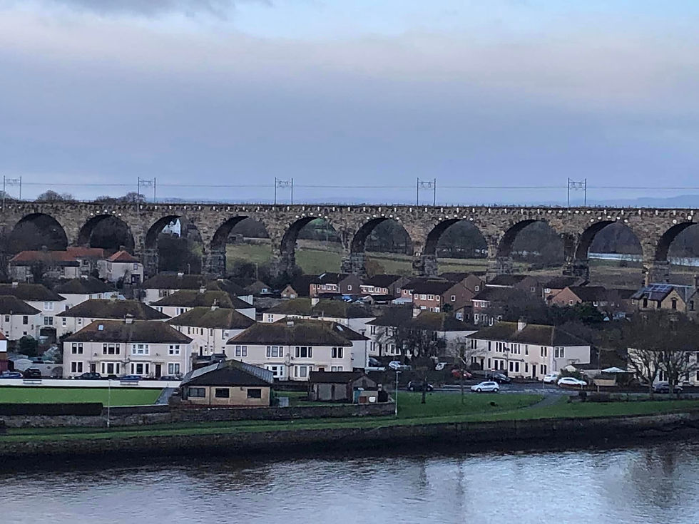
The original bridge was completed in 1624 and this solid stone crossing (pictured at top of post) replaced a series of wooden structures. It now functions as a one-way road for local traffic. The Royal Tweed Bridge opened in 1928 a little further upstream and took the pressure off the 17th-century crossing. The two new lanes greatly improved traffic flow but increasing car ownership choked this route as the century wore on. The bridge carried the main A1 road until the 1980s. A bypass was badly needed and the modern highway now runs a mile to the west. The third part of the town-centre triumvirate is the railway viaduct officially known as Royal Border Bridge. 700 yards long, it has 28 arches and has conveyed trains between England and Scotland since 1850. Along with old Berwick Bridge, the Royal Border Bridge is A-listed while the Royal Tweed crossing has to be content with B-status. A steep incline took us from the riverside up to the level of the ramparts. These massive defences were erected in the mid-1500s during the reign of Tudor queens Mary and Elizabeth. Guns were mounted in an effort to protect the border town during a time of great conflict between England and Scotland. In places, the older town walls were incorporated into the new bulwarks. Berwick has been part of England since 1482 but had changed hands a dozen times prior to this date. Even today, many Berwickers feel a close affinity to Scotland. Local sports teams often compete within the Scottish set-up, although this is also influenced by geographical practicalities. Curiously, the ancient county of Berwickshire lies wholly within Scotland, divorced from its erstwhile county town. The Berwick defences were of course modified over the centuries and new batteries were installed in the 1770s to ward off enemy ships, long after Scotland and England had been joined politically by the Act of Union.


ree

It was a very pleasant circular stroll around the military stronghold. Information boards were placed at regular intervals and cannons stood in position. We passed a historic churchyard and an ice chamber used for refrigerating salmon in the days when the main markets were several days away by boat. The fish were packed in ice prior to transportation, as maintaining the freshness yielded a far higher price than going down the pickling or salting route. Berwick Barracks were constructed in the early 18th century, following the failed Jacobite uprising of 1715. After the fateful Battle of Culloden in 1746, the Jacobite threat was extinguished and Berwick's status as a strategic garrison town waned. The barracks later became the regimental headquarters of the King's Own Scottish Borderers, an arrangement that lasted until 1963. The complex now houses a museum, although this facility is closed during the winter months. I must make a note in my diary to return. Plans are afoot to transform the unused space within the barracks into a community asset, including studio space for local artists and the relocation of the Berwick archives to the site, with suitable research facilities. Also slated is a restaurant in the officers mess and a retail unit within the gatehouse. The parade ground could host community events and there are further proposals to convert other parts of the barracks to residential use. We had now completed this fantastic little historical circuit and - after a quick bite to eat - it was time to hit the road, pausing at Eyemouth a short distance across the border. The largest town within the County of Berwick, Eyemouth boasts a natural harbour and has a fishing heritage stretching back to the 13th century. A branch railway connected to the East Coast Main Line until closure in 1962. Like many small fishing towns and villages, Eyemouth saw the industry decline in the latter stages of the 20th century but hopes were raised in 1997 when EU grants were matched by local fundraising, allowing the harbour to be modernised and able to cater for a wider range of fishing and maritime activities. We had a wander around but the town museum was closed for the winter (another note scrawled in diary).


ree

Standing in isolation across the Eye Water estuary is Gunsgreen House. The 1753 mansion has a history intertwined with the smuggling trade. Original owner John Nisbet is reckoned to have led a double life. The high cliffs of the Berwickshire coast, punctuated by narrow coves, made this part of the country an ideal location to carry out illegal commercial operations. The closest Customs House to Eyemouth was in Dunbar, 20 miles away and the local people regarded the smugglers as benefactors rather than criminals. Not difficult to see why the black market flourished here. Gunsgreen subsequently passed through many families before becoming a guest house and later a golf clubhouse. In 1998, Gunsgreen stood empty and had been virtually abandoned. It's future hung precariously in the balance. Little of value survived, windows were broken and interior spaces were partially dismantled. Salvation arrived when the Gunsgreen House Trust was established. The historic mansion has been restored and converted to a visitor attraction, telling the tale of its history and the various inhabitants. Tourists can inspect the vaulted cellars and discover the hidey-holes built into the structure, especially the tea chute - a unique survivor of the days when fortunes could be earned by smuggling this highly-taxed commodity. Unfortunately the house is currently undergoing renovation and is closed until April 2023. I now have several reasons to return to this little corner of the Anglo-Scottish border. The town centre of Eyemouth features a memorial to the 1881 fishing disaster, a tragic event that took the lives of 189 local men in a single day. Harbours back then often had tricky approaches and I've heard of several tragedies where disaster unfolded within full view of those standing on the shore as boats foundered against the rocks during violent storms. The 78 widows and 182 children left without a father are honoured in the artwork that was unveiled in 2016.


ree

Family members watched as their husbands, brothers and fathers were thrown into the churning sea and drowned before their eyes. The five-metre bronze installation - entitled Widows and Bairns - was created by Jill Watson and depicts the despair of those forced to watch the proceedings, unable to prevent the tragedy. Each figure represents a real person. The plinth contains the names of every woman and child directly affected by the disaster. The wooden boats were no match for the storm and they overturned in the open sea or were dashed against the jagged rocks around the harbour entrance. An extremely sad tale. We returned home, satisfied with our little break. The weather hadn't been too bad and a lot of history was packed into the trip. Most people in Scotland could easily reach Berwick by car or train. You should go!


bottom of page