top of page
  • Writer: Walking With Brian
    Walking With Brian
  • Apr 6, 2023
  • 4 min read

Updated: Apr 30, 2023

Large cities offer many walking routes but of course the pool diminishes as you progress. I purchased a self-published e-book a while back that outlined a selection of Glasgow wanders, but found I had already done most of them, or close variations thereof. One diamond shone brightly in the rough - the Drumchapel Way. This 4.5-mile circuit skirts a housing estate on the edge of the city and offers extensive woodland and parkland sections. There is a handy rail connection from Glasgow Queen Street and I duly filed the outing on the to-do list.


ree

I eventually tackled the route when on the lookout for an inexpensive day-trip during my Easter break. I took the bus to Glasgow and walked the short distance to Queen Street Station, now extensively remodelled. The rather depressing 1960s architecture has been replaced by a modern glass frontage and spacious interior concourse as part of a £120 million project. My train out to Drumchapel was due to depart from a low-level platform and I descended to the subterranean part of the station. The journey initially began inside a lengthy tunnel but I was soon spotting city landmarks and enjoying views of the River Clyde. I alighted at Drumchapel and walked a few hundred yards to the shopping centre, the official start point of my walk. Social scientists could no doubt make a few interesting observations in this deprived far corner of Glasgow. A vape shop took pride of place in the concrete precinct and the queue at Greggs Bakery spilled out on to the pavement. I crossed the road and took a photo of the information panel displaying the route map. I had read the marker posts were haphazard within the urban stretch and I was directed to pass two tower blocks and follow the edge of a public park. I crunched along a tarmac path covered by a carpet of broken glass before switching to a grassy trail. New low-rise housing stood nearby and I would encounter plenty of empty space within the scheme, suggesting that some demolition had been carried out over the years. I walked by the Donald Dewar Sports Centre, named after the Glasgow native who became the inaugural First Minister of Scotland following the re-establishment of the parliament in 1999. After just one year in office, Dewar suffered a brain haemorrhage and died the following day.


ree

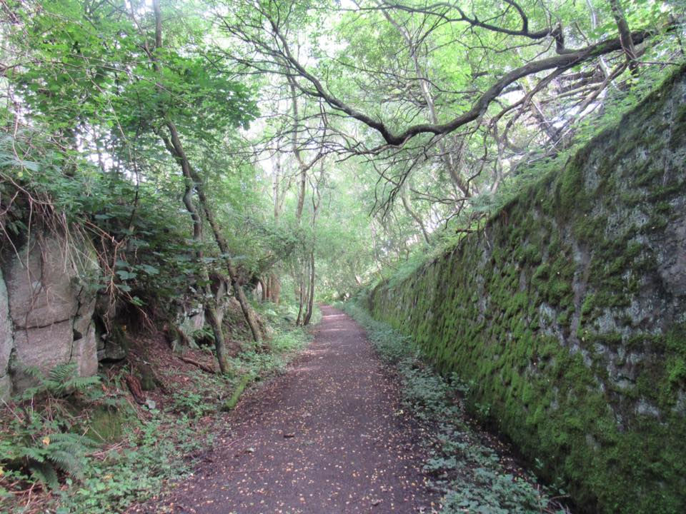
Originally a rural location within the County of Dumbarton, Drumchapel was transformed beyond recognition in the 1950s when civil administration was transferred to Glasgow Corporation and a large housing estate erected. The development was intended to accommodate 35,000 people and formed part of the overspill policy which entailed slum clearance in the heart of the city. On the surface, it must have been a easy sell. To move from an overcrowded and run-down tenement block where four households shared one external lavatory, to a modern spacious home with a private bathroom would have represented a big advancement in living standards. It made sense on the bricks and mortar side, but the mass building programme failed to replicate the sense of community. The amenities proved woefully inadequate and anti-social behaviour soon abounded. The terminal decline of Glasgow's traditional heavy industries would not have helped matters. The current population of Drumchapel is less than half of what was originally envisaged but on a positive note, great efforts have been made to regenerate the area over the last quarter of a century. It certainly wasn't a threatening place and the path swung away from the estate to enter Garscadden Wood. On the other side of the trees lay the affluent district of Bearsden - the very definition of leafy suburbs.


ree

The path began to climb and I could see across the whole of Drumchapel and into the rural territory and shallow hills beyond. I was right at the city limits and I observed a couple of squirrels before encountering two deer chewing on green vegetation. I slowly reached for my camera and managed to reel off a few nice shots before they scarpered. I continued my arboreal ascent but the presence of discarded alcohol containers reminded me I wasn't fully out in the sticks. Thankfully, some of the detritus had been bagged up, awaiting collection. Planes passed regularly overhead en route to Glasgow Airport, near Paisley. I gradually dropped back down to street level and the trail skirted the foot of a small mound topped by an enormous water tank. The futuristic concrete tower resembles an invading spacecraft from War of the Worlds and is supplied by the Loch Katrine reservoir in the Trossachs. It delivers a steady pressurised output to the Drumchapel households and is a prominent local landmark. I re-emerged in residential territory and passed a brand new allotment site. As I worked my way back to the shopping centre, I tried to make sense of the enormous quantities of litter that blighted the area. Every vacant piece of land was strewn with cans and bottles of all descriptions, along with an assortment of other waste. Hedges and bushes sagged under the amount of trash lobbed into them. It was disappointing to see, given the numerous obvious efforts being made throughout the area to improve its appearance. Apparently littering is very closely linked to social deprivation. You would need an army of volunteers to clean up the mess here. I wandered back down to the railway station. It had been an interesting walk through a less salubrious part of Glasgow, but one with its own distinct character.


  • Writer: Walking With Brian
    Walking With Brian
  • Mar 2, 2023
  • 8 min read

Updated: Mar 13, 2023

Virtually all my blog posts are written a short while after the event. I do occasionally piece together a report from memory, aided by Facebook images and comments from the relevant date. This week, I physically revisited a walk I'd undertaken a few years previously. Nicole was travelling up to Dundee for her part-time university course and I dropped her off before taking the car a few miles further north into Angus. The village of Newtyle is ringed by the Sidlaw Hills and the settlement grew around the terminus of Scotland's first commercial railway, which explains the regular grid plan of the main streets.


ree

The Dundee & Newtyle Railway opened in 1831 and was rather Heath Robinson in its original form. The gradients were too steep in places for conventional traction and three rope-hauled inclines powered by stationary steam engines were implemented. This included a tunnel below Dundee Law. The relatively flat sections were serviced initially by horse power and later upgraded to locomotive working. The convoluted scheme proved tedious and maintenance costs were high. The original intention of the railway was to facilitate the movement of agricultural and jute products but passenger traffic was also buoyant. In 1860, work began on by-passing the inclines and three sweeping deviations were constructed. Continuous trains commenced operation in 1868 and this arrangement continued for almost a century until the final goods service ran in 1967. Like many rural routes across the land, the Dundee & Newtyle Railway had struggled to compete with the rapid post-war rise of road transport. Passenger trains had ceased 12 years earlier. Some remaining infrastructure around Newtyle has been converted to walking paths and it was this little network I planned to investigate. As it turned out, I would also discover other fascinating artefacts slightly off piste. Anyone wishing to explore the local area should call in at the village shop and buy the pack of slim booklets detailing the various trails. The railway path begins at the public park but I followed the advice in the leaflet to walk 200 yards along Commercial Street to check out the original railway terminus and extant engine shed (pictured above). The stone building was shuttered but otherwise looked to be in reasonable condition. The alignment of the 1-in-13 Hatton incline down to the village could be picked out and I was able to examine the remains of the passenger platform. The rebuilding of the line included a new station on the north side of the village but the train shed remained in use and a link was left in place. Things had changed on my second visit, with the old buildings now in the process of being converted to residential apartments. It will safeguard the future of what must be some of Scotland's oldest railway real estate. What a cool place to live!


ree

I headed back to the park and proceeded along the signed path. The initial stretch was the beginning of an early two-pronged extension to the original railway which connected Newtyle to Coupar Angus and Glamis. Neither of these routes proved particularly successful but they found a new lease of life after being subsumed by an express line. More of that soon. I noted the outline of a railway turntable around the point where the northern extension would have merged with the realigned approach to Newtyle. The modernisation project included a branch to Alyth which closed to passengers and goods in 1951 and 1965 respectively. I enjoyed fine views of Kinpurney Hill as I strolled along the embankment. A square tower stands upon the summit and was erected in 1774 as an observatory. I climbed up here following my first exploration of the Newtyle railway network and enjoyed the panorama of Angus and Perthshire blurring together and also the distant Grampian Mountains. I curved round to meet the B954 where the bridge was missing. This was the point where the Alyth line diverged. The path continued for another 800 yards upon an embankment between the fields before descending to meet a minor road where another bridge was long gone. The signed railway route ends here but it's possible to continue another mile and a half towards the tiny village of Ardler along the trackbed of the Scottish Midland Junction Railway - which blazed a trail between Perth and Forfar, before continuing onwards to Aberdeen via Kinnaber Junction, north of Montrose. This inland main line emerged in the mid-1840s during a frenzy of railway building and the handful of companies involved were absorbed into the Caledonian Railway conglomeration by 1866. The high-speed artery competed favourably with the coastal connection to Aberdeen, nowadays known as the East Coast Main Line. The original extensions to the Newtyle Railway sat on the perfect axis for this new scheme and were duly taken over. The path I had just completed merged with the main line just beyond the point where I now stood. I didn't have time to continue to Ardler today as I intended to back-track along the partially overgrown Caledonian line and also explore the roundabout approach to Newtyle from Dundee that avoided the fearsome Hatton incline.


ree

A rough path snaked along the Caledonian trackbed back to the point where the railway passed underneath the B954. This is also the sight of Alyth Junction Station, which closed in 1967 along with the entire main route, although freight was retained between Perth and Forfar until 1982. Ultimately only one corridor to Aberdeen could survive the Beeching axe of the 1960s and it wasn't to be the Caledonian option. A tragedy really, as the tracks didn't remotely duplicate the coastal run, apart from the final shared stretch to the Granite City. I wandered alongside the ghostly platforms and tried to picture steam expresses thundering through this quiet rural spot. The Alyth branch passed over the Caledonian territory and the bridge supports are still in place. Such a sight is common enough when exploring dismantled routes. Much rarer is the presence of lineside telegraphy infrastructure. The odd rotting wooden pole can be spotted here and there but today I encountered a complete specimen with hanging wires and insulator pots pretty much intact. I've yet to see a better "in the wild" example of this anywhere else. If you look at old railway photographs, you'll notice most routes had wires strung alongside the tracks. This wasn't just for signalling purposes. The railways provided convenient corridors for linking up towns with the new telecoms technology. Eventually it all went underground, although you still sometimes see telegraph poles following unclassified roads, and certain villages have retained the heritage aspect of wires criss-crossing the main street. But no modern railways are flanked by telegraph poles. The Victorians could never have imagined that one day this wired network wouldn't just convey human voices, but all manner of complex data as the embryonic internet took shape.


ree

An even more surprising piece of equipment stood near the old flyover. A tall semaphore signal reached up through the surrounding foliage to a considerable height. Normally these metal towers were removed for scrap and it's anyone's guess why this example was left in situ. The bolted-on ladder ran all the way to the top and it felt remarkably solid. I only climbed a few rungs as far as the (now rotting) wooden platform that must have been used for maintenance inspections. Had I gone higher I could probably have re-enacted the Castlemaine XXXX lager advert from the late 80s - I can see the pub from here! It would almost have been a true statement as the Belmont Arms is situated next to the old Alyth Junction station, but sadly a victim of Covid closures. I retraced my steps to the end of the official railway path and it's worth noting that a major accident occurred here in 1948 at the point where the two lines spliced together, which happens to lie along the Angus Perthshire boundary. A local train from Newtyle collided with a Royal Mail express bound for London Euston. The engine of the latter was separated from the tender and ended up on its side in a field, demolishing a bridge parapet in the process. The running speed on the main line was 90mph and two crew members were killed - the driver of the local service and the fireman on the high-speed train. Eight passengers plus the two remaining footplate staff were taken to Dundee Infirmary. The tragedy could easily have been far worse as an excursion train was steaming towards the crash site and the presence of lineside tar boilers was obscuring visibility. Fortunately the driver noticed a danger signal at the last moment and slammed on the anchors, bringing his train to a stop just five feet short of the wreckage strewn across the tracks. An additional hazard was the throng of uninjured passengers from the local train milling about trackside, many in a state of shock. I continued to the hamlet of Newbigging and hooked up with a right of way, known as Water Backie Path. This allowed me to rejoin the course of the Newtyle Railway.


ree

The final part of my planned walk was an exploration of the curving deviation constructed in the 1860s to avoid the sharp Hatton incline. The path runs through an atmospheric moss-lined rock cutting known locally as the Gullet. The sunken strip must surely be a haven for rare plant life and the gradient was very noticeable as I tramped uphill. The locomotives would have required a good head of steam to negotiate this loop. I passed a couple of obvious side paths leading back to the village centre and pressed on until I reached an area of woodland that had suffered heavy storm damage. An old quarry lay beyond and the going became increasingly muddy. I therefore decided to turn back and I varied my route by cutting through a field in order to check out Hatton Castle on the edge of Newtyle. It occupies slope facing towards the foot of Hatton Hill, with good views across Strathmore. There is a strategic reason for a fortification here as the castle guards the northern end of a pass through the Sidlaw Hills. The tower house was built in 1575 on a Z-plan, which comprises a strong central rectangular section with smaller towers attached at diagonally opposite corners. The building was forfeited and de-roofed in 1720 following the Jacobite rebellion and fell into ruin, the new estate owners choosing to build a mansion elsewhere. Restoration work was undertaken in the 1980s and the castle is now a private family home. The Great Hall has stunning acoustics and several memorable dances and concerts have been held. It is a regular gathering place for Scottish traditional musicians, notably hosting the creative network Fiddle Force.


ree

I wandered back into the centre of the village and called in at renowned butcher James Pirie & Son for a well-earned snack. Established in 1960, the shop has won multiple industry awards over the years, including a trio of victories in the World Scotch Pie Championship. James worked into his late 80s and became Britain's oldest butcher. The business is now in the hands of his son Alan and I couldn't pass up the opportunity to sample some of the wares. A couple of individual steak pies went down a treat and restored my energy levels. I drove back to Dundee to collect Nicole and wondered about that old tunnel under the Law (never Law Hill, by the way). The 360-yard bore opened for business in 1831 but was superseded by a deviation via Lochee. Mushrooms were grown within the dark interior for a few years but the tunnel fell out of use, being brought back into service as an air-raid shelter during WW2. After many decades of exploration by intrepid local youngsters, the ends of the tunnel were sealed in 1981 as development work took place around the old portals. The subterranean passage however remains intact and receives an internal inspection every three years. One lucky householder has an access hatch in the back garden. There have been campaigns to open the tunnel as a public attraction. We live in hope.


  • Writer: Walking With Brian
    Walking With Brian
  • Feb 20, 2023
  • 6 min read

Updated: Feb 22, 2023

An Irish Sea inlet known as the Solway firth cuts a wedge between southwest Scotland and the northern English region of Cumbria. We had previously explored parts of the Scottish side but this would be our first foray along the opposite shore. While planning the trip, I had scouted out an RSPB reserve near the village of Bowness, which also happens to be the end point of the popular Hadrian's Wall walking trail - a route I'd love to tackle one day. Nicole booked a Travelodge just off the M6 and we set off around 11am on a blustery Friday. A storm had raged the previous night and was now thankfully blowing its last.


ree

The M74 is an unlikely candidate for one of Scotland's great scenic drives. Once past the densely populated parts of Lanarkshire, the three-lane motorway winds its way through the Southern Uplands. The highway becomes the M6 as you cross the border but otherwise your journey continues unhindered. We had to turn off just before Carlisle to briefly take the A689 before diverging on to country roads along the Solway Firth. The nature reserve could wait until the next day but, with several hours of daylight still available, it made sense to get a feel for the area, rather than sit in a hotel room. We passed through a couple of tiny villages and noted the signs by the open roadside, stating that water levels on the long flat shore stretch could rise to two or three feet. That sounded rather ominous! The tide was pretty far out and we surmised the warning only applied during exceptional times and that the flooding didn't occur on a daily basis. Our theory was thankfully confirmed by a local resident as we parked at the far end of Bowness village. The views across the estuary to Dumfriesshire were simply stunning. We walked back through the narrow streets and examined the village church, constructed from salvaged parts of Hadrian's Wall. This convenient supply of stone provided local builders with a ready supply of material and as a result the fortification has vanished from the landscape at its western extremity. Unfortunately the tearoom had closed shortly before our arrival but the village pub was open. I ordered a pint of Corby Blonde - a local Carlisle brew. We were the only customers but a few people trickled in behind us. The area will be much busier during the warmer months when tired walkers troop into town.


ree

We've all heard umpteen variations of the joke that speculates why the chicken crossed the road. But do we ever see poultry attempt this risky manoeuvre? During my half century on this planet, I didn't think I had. Until today. A handful of splendidly chunky birds strutted across the asphalt, prompting a van driver to halt, wind down his window and cheekily ask which one I fancied for tea. Life is indeed conducted at a slower pace around these parts! The incident also posed the question whether tomorrow's visit to the bird sanctuary could top what we'd just witnessed. We took the same road back towards Carlisle and detoured up to the small village of Rockcliffe to visit a country pub that had been recommended to us. The Crown & Thistle was bustling with drinkers and diners. I ordered a pint of Cumbrian bitter while Nicole sipped an artisan lemonade. A couple of comfy armchairs in the corner enabled us to relax and plan our activities for the next day. We slept soundly back at the hotel and were up early for breakfast at the nearby Morrison's Café. Six quid for a full English. Can't complain about that! I now knew the road out to Bowness and we continued the extra mile to RSPB Campfield Marsh. The reserve is staffed and a friendly welcome awaited us at the small visitors centre. The site is a mosaic of saltmarsh, peat bogs, farmland and wet grassland. This rich area is home to a variety of native wildlife, including ducks and geese in the winter and breeding waders, dragonflies and rare plants over the temperate period. Two circular trails have been created but the recent rainfall had rendered the smaller paths very muddy and we opted to stick to the farm track that led to a couple of bird hides. The first viewing area was worth the trip in itself. Dozens of lapwings splashed about in the pools while redshank and shoveler were also well represented. Nicole spotted a pintail but I missed out on that one. One of the volunteer rangers explained the wetland had been restored after many years of agricultural use. Initially this move provided a generous buffet for local foxes and electric fences had to be erected to keep the vulpine visitors at bay. It's often impractical to simply leave a newly-formed wild space to its own devices. An inevitable consequence of centuries of human tampering, but preferable to endless sheep and cattle enclosures.


ree

The hide at the far end looked out over a peat bog but not much was happening today. On the way back we spotted a teal sitting on the grass. It was the first time we had seen our smallest duck out of the water. These dabblers have a vivid colour scheme (or at least, the males do) and it was fascinating to catch a glimpse of the breast which normally can't be seen when the teal glides around on a lake or river. We were more than satisfied with what Campfield Marsh had to offer. We didn't spot the snipe but you can't have it all. A bittern had recently been sighted around here but the closest I came to success was finding a metal pin badge of this quirky heron in the reserve shop. Another emblem for my RSPB hat. Got to keep up with fashion and trends. We drove a little further down the firth and pulled into an elevated lay-by for lunch. A scenic spot for sandwiches. Signs asked people not to descend to shore level as the territory was an important habitat for local wildlife. The thick gorse bushes would have provided a deterrent anyway, but perhaps not to dogs. Let's hope the advice to keep them on a lead at all times is heeded by all pet owners. I wouldn't stake my house on that. Our next port of call was Drumburgh Moss - accessed by driving a few hundred yards down a wide dirt track. The pot-holes weren't too bad and in any case Dolly Duster makes light work of indentations. The moss is owned by the Cumbrian Wildlife Trust and is a site of international importance, dominated by an expanse of lowland raised mire, one of Western Europe's most threatened habitats. Sphagnum moss, sundew and other bog plants thrive in the wetlands that make up much of the terrain. Adders are present and a herd of wild Exmoor ponies roam at will. Again, it was too slippery to contemplate a circuit but the hide was easily accessible from the parking area. We didn't see many birds but as we ascended the staircase to the entrance door, I noticed a few brown shapes in the distance.


ree

The binoculars confirmed we had located the little horses and they were happily munching away on the ground vegetation. This made it difficult to take a photograph containing the head but eventually I got lucky. Peat bogs were formed over many thousands of years. Basically they resemble a giant sponge and the terrain is vitally important for carbon storage. Then along came humans with fanciful ideas of animal husbandry. Large areas of mire were drained across the UK and peat was cut for domestic fuel. These activities have left surviving patches of bog drier than they should be. The trust is attempting to reverse this process by blocking ditches, reprofiling peat faces and removing unnecessary trees in order to raise the water level to a more natural state. A fascinating place and one to return to in the summer. The longhorn cattle didn't put in an appearance but the ponies were the main prize. Native to the British Isles, the breed came close to extinction during WW2 when many were shot for food. The situation remains precarious and the global population is around 350. Let's hope they can hang on. Light was starting to fade and spots of rain were evident. The forecast had been dire and it was certainly a bonus to have avoided a soaking as we explored the Solway. We drove back to the M6 and wet conditions were soon encountered. It had been an excellent short break in a corner of England we had never visited before.


bottom of page