top of page
  • Writer: Walking With Brian
    Walking With Brian
  • Nov 16, 2023
  • 7 min read

Updated: Dec 5, 2023

The newbie cities of Dunfermline and Stirling were once linked by a mainline railway. Passenger services ceased in 1968 and the last freight train ran in 1986. Nowadays the old trackbed hosts an 11-mile walking and cycling path with a tarmac surface. This rural artery runs from the Western edge of Dunfermline to the fringes of Clackmannan, whereupon new rails take over (more of which later). As a public transport enthusiast, it's a personal bone of contention that there's not even a direct bus service between Dunfermline and Stirling - two places with city charters, a shade over 20 miles apart. Surely this corridor is a prime example of low-hanging fruit in terms of building a greener travel network.


The cycleway was constructed sometime in the 90s. I definitely rode the entire length in 1999 and walked a portion a few years beforehand. Since moving to Cairneyhill, I have traversed the old railway on many occasions, including the full distance on foot two or three times. Prior to styling myself as a walker, the path formed a project that I split into several manageable chunks. Back then I merely wanted to explore the infrastructure and approached the task with my train hat on, never giving a moment's thought to one day tackling the 11 miles in one go. That in itself illustrates how far I have progressed on my two-legged journey. Autumn is an ideal time to visit. The broadleaf trees display their fabulous colours and the temperature is cool. The firm flat surface is easily accessible and you can do the walk in a comfortable pair of trainers. I set off on a Sunday morning in early November and took the bus through to Clackmannan. I crossed the working single-track line that passes through the town today. A station was located at this point but it closed as far back as 1930. This eastern end of this railway originates near Dunfermline City Station and it runs right through the derelict site of Longannet Power Station (closed 2016) before reaching the small towns Kincardine and Clackmannan. The track formerly joined the trunk Dunfermline & Stirling route on the outskirts of Alloa. Passenger numbers via Kincardine were always low and were scrapped in 1930 but the line was retained for goods traffic. Spanish train manufacturer Talgo was set to move into Longannet but the development - announced in 2018 - appears to have hit the skids. The existing rail connection had been an obvious selling point initially. A failure to secure lucrative HS2 contracts is being touted as the reason for the apparent withdrawal. Part of the package involved extending the Stirling to Alloa passenger service (re-opened 2008) as far as Kincardine. Wider proposals to use the corridor as a direct Dunfermline to Glasgow link are still at the talking stage. The original mainline formation took a more direct inland route from Dunfermline Upper (demolished 1990) towards Alloa and grazed the edge of Clackmannan.


The above diagram shows the principal line from Dunfermline Upper running through the centre. My walking trail for today. This connection was fully operational by 1852. The second (and slower) route from Dunfermline Lower (now City) hugs the coast and was built in two stages 13 years apart, hence the different colours on the map.


I wandered down to join the cycleway at the point where Clackmannan Road Station was situated. It closed as early as 1921, probably because the other line offered a more central option. I set foot on the tarmac and almost immediately crossed a viaduct over the Black Devon River. Mineral lines and tramways diverged here to serve coal pits and a tile works. In the opposite direction, the overgrown embankment continues for half a mile towards the place where the two westward routes from Dunfermline merged (confusingly called Kincardine Junction). A surviving trackside industrial landmark is the tall chimney upon the site of Cherryton Brickworks - opened in 1935. The plant closed without warning in 1976, apparently with a full order book. Almost 30,000 bricks were being churned out daily at the time of the demise and modern machinery was lending a hand. Freight trains were able to reverse into the yard and waste material from nearby collieries was a vital ingredient in the production process. The post-war social housing boom created a huge demand for bricks. The remains of the Cherryton kilns and outbuildings can be found in the undergrowth but I pressed onwards and soon crossed the A977. This marked the site of Forest Mill Station, originally known as Kincardine & Kennet, despite lying three miles from the former. A name change was enforced when Kincardine received a more suitable station in 1893. The trackbed broadened out in front of me, indicating the one-time presence of sidings. Indeed, Forest Mill handled goods until 1979. Passenger trains last stopped here in 1930, a year when many halts across the land were axed due to poor patronage.


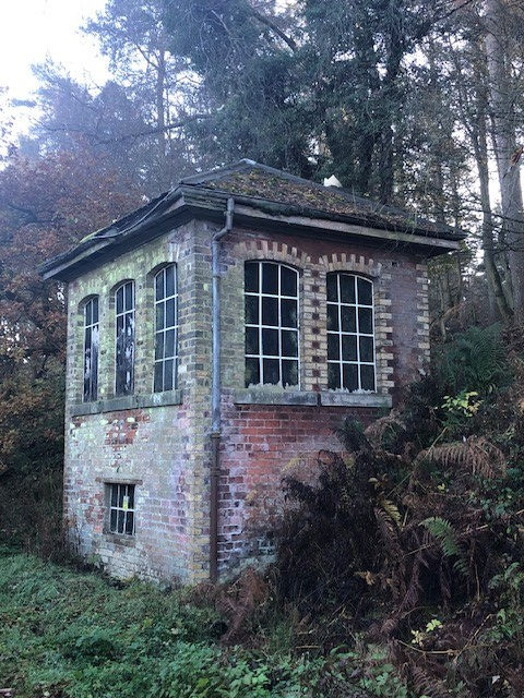
The trail passed through Slack Wood and crossed the Clackmannanshire Fife boundary at a minor road overbridge. The remains of a loading bank can be spotted by the trained eye here. Most likely it was used to transfer agricultural produce. A derelict cottage stands close to the trackbed and tucked out of sight around a bend is the A-listed Brucefield House. The surrounding estate encompasses over 400 acres and three luxury eco-bothies are available to hire, along with Slackbrae Cottage. A long straight section of path brought me to the site of Bogside Station. The signal box and wooden waiting room building survive but are showing signs of wear and tear after decades of exposure to the elements and lack of care and maintenance. The waiting room is now almost completely engulfed by vegetation. It's nice to see old station infrastructure feature on the trail and I hope the Bogside buildings remain for years to come. The signal box ceased to function in 1973 when the (freight-only) line was singled. It would make an excellent little heritage centre today. The line was pared back to this point from Kincardine Junction in 1979, thus severing the direct link between Dunfermline and Stirling along the original high-speed course. Bogside Station had closed to passengers back in 1958 but gunpowder traffic to the Muirside explosives depot continued into the early 80s. There was also a short mineral spur leading to Bogside Mine, one of several West Fife collieries feeding Longannet Power Station. An underground network of conveyor belts was eventually developed to transport coal directly to the furnace. The mine was abandoned in 1987, following flooding and gas issues that had built up during the bitter national miners' strike a few years beforehand. Bogside as a settlement is little more than a hamlet and I was very much in rural territory. As I skirted the northern edge of Devilla Forest, I met someone riding a horse along the path. The next halt on the line was East Grange but all traces of the platforms have vanished. A small goods yard was located here and - like Bogside - passenger services disappeared in 1958. Perhaps footfall was deemed viable in Victorian times when far more people worked on the land. The station master's house still exists as a private residence. The path ran through a lengthy cutting and brought me to the eight-arch Dean Viaduct - the most complex piece of engineering on the entire route. The decking is now tarred and I looked down into the wooded gorge below. The short branch to Blairhall Colliery is now a footpath. This pit closed in 1969 but nearby Comrie continued producing coal until 1986.


As I approached the site of Oakley Station, the presence of brick retaining walls and the widening of the trackbed provided clues of former activity. Passenger trains ran until 1968 and a signal box controlled the junction for Comrie Colliery. The system was rationalised in 1982 when the westward rails to Bogside were lifted and Comrie became the end destination from Dunfermline. The showpiece pit had opened in 1939 and featured all the latest engineering wizardry underground. Surface facilities included a smokeless fuel plant and an aerial ropeway to the bing. By the 1980s. three quarters of the mine's output was sold directly to the electricity board. One has to wonder if the government forced the eventual closure out of sheer spite, following the lengthy industrial dispute that polarised society. The decaying rump of a once-grand railway now had no use and the remaining track was removed all the way back to the junction with the present-day Fife Circle line at Dunfermline Queen Margaret Station. Oakley village grew in conjunction with the coming of heavy industry to West Fife and is the only lineside settlement of any real size between Dunfermline and Clackmannan. Therefore the station survived until the final withdrawal of passenger services. I now had three and a half miles ahead of me to the end of the cycle path. It was a pleasant wander between fields on a slight uphill gradient. The walkway comes to an end at William Street on the edge of Dunfermline. A mineral railway system diverged a little further back and ran out to Kelty, Steelend, Lochore and onwards to Thornton. The William Street bridge was dismantled in the late 80s and cyclists and pedestrians must descend to pavement level. This is a pity as the embankment does continue beyond private property on the opposite side and runs another half mile to the Buffies Brae viaduct near the city centre. Although it's not difficult to find an access point on foot, this final stretch now resembles a jungle in places and is an increasingly awkward explore. Apparently SusTrans purchased the land for £1 but the upgrade costs will be high and the logisitics difficult. Beyond the disused footbridge at Phoenix Lane, a few houses adjacent to the line appear to have snaffled parts of the trackbed as garden extensions. Naughty! There is no public access to the viaduct at Buffies Brae, although yours truly has been up there a couple of times. It is possible to leap across the Baldrige Burn and scramble up a very steep slope on hands and knees.


Beyond the viaduct, the rails ran through a deep narrow cutting (now infilled) towards the site of Dunfermline Upper Station, pictured above shortly before demolition. A retail park was built here in the early 90s and put a permanent obstacle in the way of the route ever re-opening. Beyond the football stadium (rear of picture), the walking path continues along to Queen Margaret Station, site of the old junction. A triangular set-up allowed easy access between the Upper and Lower (now City) stations. Closing the Stirling line would be unfathomable in today's political climate. Sadly in the 60s, it was a different story altogether.


The track between Longannet and Stirling had been quietly decaying since the early 1980s as opencast coal was brought in from the opposite direction. The return of passenger trains on the Stirling to Alloa portion in 2008 also included a renewed freight link to the power station in order to remove coal trains from the Forth Bridge. Scotland had switched to importing coal via the deep-water port at Hunterston, Ayrshire. It made sense to convey this traffic via Stirling, avoiding the busy Forth Bridge (not to mention the complex reversing arrangements that followed). We now have rails in place all the way between our two ancient royal capitals, theoretically ready to go. Will they ever reach their potential?


  • Writer: Walking With Brian
    Walking With Brian
  • Nov 7, 2023
  • 10 min read

Updated: Dec 5, 2023

Northumberland has been a regular destination for Nicole and I over the past few years. England's northernmost county can be reached in a couple of hours and offers spectacular coastal locations. We booked a four-night stay in a static caravan during my October holidays and the site was next to the coastal town of Newbiggin by the Sea. Off we set in Dolly Duster for another journey down the A1.


Budle Bay, near Bamburgh, is a regular port of call when we head south. Scores of wading birds and ducks can be seen on the vast mud flats when the tide is out. The area is part of the Lindisfarne National Nature Reserve and very popular with birdwatchers. On any given day you'll see people gazing through spotting scopes across the flat terrain. Groups of walkers often pass, although the Northumberland Coast Path doesn't actually skirt the shore here. It must be a popular deviation from the official route! We pulled over at the lengthy parking strip and Nicole began to assemble her new scope and tripod. The clarity and range is far better than what can be obtained from regular binoculars. Vague distant blobs in the viewfinder of the latter are transformed into readily identifiable birds by the superior lens. The downside of the scope is having to carry the kit around and also the process of setting up and dismantling. Nicole spotted a golden plover strutting along the shoreline and I captured it with my camera. This shy bird changes its plumage in winter and eats mainly worms, beetles and other insects. We drove back to the A1, being halted at one of the many level crossings in this neck of the woods. The East Coast Main Line slices through all the minor roads that run out to the coast. We left the dual carriageway at the turn-off for Ashington and Morpeth, the nearest large towns to our caravan park. We stopped at Asda on the outskirts of Ashington to stock up on provisions and navigated our way to Sandy Bay. Owned by Parkdean Resorts, the site had a very similar feel to Grannie's Heilan' Hame in Sutherland, where my folks had a static van for many years. We had booked this trip on Air B&B and were renting the accommodation from a private owner, rather than Parkdean itself. Our unit was parked on a slope and had a partial sea view. For those not familiar with statics, they are plumbed in and have gas and electricity supplies. The interior is like a small apartment. Lounge, kitchen, toilet & shower, double bedroom and twin room (essentially for kids). Insulation is extremely thin and October is realistically the last month of the year you can stay in comfort.


Towels, bedding and kitchen equipment were included in the hire. The lounge had a TV and a selection of board games and DVDs. Wi-fi was available down at the reception and entertainment block. Ominously, a major storm was forecast for our final day and we planned to do as much exploring as possible before the rain came. After unpacking and stocking the fridge, we cooked dinner then headed along to Newbiggin by the Sea as sunset approached. The small town had a lovely High Street and we parked by the Maritime Centre on the shore. The waves were crashing against the rocks, making weird and wonderful white shapes. The church overlooking the water was subtly lit by the fading sun. A real picture postcard scene. We wandered along the coastline and came across a natural phenomenon. A fine salty spray emerged from an opening on top of a large rock a couple of seconds after each wave struck the shore. The sea must have gouged out a passage below and the air pressure was creating a blow-hole effect. We watched the sun go down and returned to the caravan for the night. The itinerary for the first full day was nature themed. First of all, a beer run to Northumbrian Gifts in the industrial estate a few minutes from the campsite. Formed in 2004 to promote, distribute and retail the finest produce from the counties that once formed the ancient Kingdom of Northumbria, the business apparently offers the biggest selection of Northern English beers anywhere in the country. There were also a few ales from the Scottish border regions. I couldn't believe my luck when I searched for a local beer stockist and discovered it was virtually next door to our accommodation. The warehouse premises had a small retail store and the shelves sagged under the weight of bottles. Thankfully no new-fangled craft cans on display, just traditional refreshment. There must have been a couple of dozen breweries represented. Choice galore. I picked out eight beers of varying style and was delighted with my haul. The shop also sold preserves, biscuits, chocolate, candles and assorted snacks. There were also local maps and books on offer. We drove back to Newbiggin for a spot of birdwatching. It gave Nicole the opportunity to test the scope over a wild seascape.


We chatted to a couple of fellow birders who briefed us on the wildlife around these parts. We spotted golden plover (again), turnstone, low-flying cormorants and the perennial seaside favourite, the sanderling, scuttling along the beach in time honoured fashion. Out in the sea stood the Couple Sculpture, erected in 2008 by Sean Henry. The painted steel and bronze artwork stands 300 metres from the shore and depicts a man and woman on a raised platform, gazing towards the horizon. The overall height is 12 metres. I had a clear view through my binoculars and I also picked out the smaller version on land. Not really my thing, but if the sculpture brings people into the town then all is good. Leaving Newbiggin, we drove a few miles up the coast to Cresswell Pond Nature Reserve. We had been here the previous summer and were treated to the spectacle of several avocets, along with my first ever confirmed sighting of dunlin. Today the water level was much higher owing to the recent wet weather and a variety of ducks were swimming around. We had the spacious hide to ourselves and scanned the shallow brackish lagoon that lay before us. Formed as the result of collapsed mine workings, it provides a year-round haven for waders and the reserve is looked after by the NWT (Northumberland Wildlife Trust). Birdwatching is unpredictable. You can be observing a pleasant, if unremarkable scene when suddenly something catches your eye. Nicole identified a snipe nestled in the longer grass in the vicinity of the hide. The long straight bill is its trademark and this was only the third time I had seen this species. A medium-sized wader, the snipe feeds on small invertebrates and 80,000 pairs breed in the UK, with up to a million single birds spending the winter here. These numbers may sound healthy but the population has suffered a decline - particularly on wet grassland - and the conservation status is rated as amber. We observed the little chap for at least half an hour, quietly minding his own business. An experience that made our day.


Back at the caravan, we settled in for the evening and prepared a meal. The kitchen drawer lacked a small chopping knife and we had dropped into Asda to pick one up, only to discover buying a single vegetable knife is now forbidden and they only come in packs. An initiative to drive down crime. Really? They should try a similar strategy in America. No Sir, I'm not allowed to sell you this semi-automatic pistol on it's own. But if you'd like to buy five of them, you can arm your buddies as well. The next day was a little unsettled weather-wise. The forecast was for a bright afternoon and we opted for an indoor activity before lunch. The Newbiggin Maritime Centre is run by volunteers and offers a three-gallery museum, café, gift shop and a large function room. We bought a handful of postcards and paid £2 each to enter the museum. Newbiggin developed around the fishing trade and vast quantities of herring and salmon were transported by rail, bound for Newcastle and onwards to London. The industry clings on but has declined over the decades. Coal was mined in the area until the 1980s and the site of Woodhorn Colliery now hosts an excellent museum. Nicole and I visited after the lockdowns when we stayed in Amble, further up the coast. Tourism has always been important to Newbiggin and in Victorian times it was the most popular seaside destination in the county. Up to 30,000 people would throng the beach on a sunny bank holiday. The railway terminus closed in 1964 but most of the line from Newcastle remained in use for freight, mainly to supply the coal-fired Lynemouth Power Station (now converted to biomass). The good news for local commuters is that passenger services are set to resume in 2024 between Ashington and Newcastle, with a journey time of 35 minutes for the entire trip. The rails won't reach Newbiggin but the station at Ashington has been designed with possible future expansion in mind. Other towns served will be Bedlington and Blyth.


A traditional fishing vessel in northeast England is the coble. Unlike larger keelboats used for deep-sea expeditions, the coble is ideally suited to the inshore task of catching salmon, crabs and lobsters. In 1868, local fishermen helped bring the first telegraph cable from Scandinavia ashore. On land, the communications pipeline was placed in trenches that led to Cable House just off the promenade. To test the system, a telegram was sent to Queen Victoria. Although the technology seems remarkably quaint nowadays, it represented a huge leap forward in global connectivity at the time. Information could now be rapidly relayed between countries and even continents. Newbiggin has had a lifeboat station since 1851 and the volunteer crews have saved over 650 lives since the first rescue launch. Rocket signalling and sailing craft have given way to electronic navigation and high-speed engines but the fundamental principle of racing to aid those in difficulty hasn't changed. Rivalries at sea are put aside when life is in danger. The museum recounted several tales of heroism and an actual lifeboat was on display. The Mary Joicey (hand built in Fife) served from 1966 until 1981 and brought 90 people safely ashore. A large amount of material is contained within the galleries and the admission charge is modest. Highly recommended. Like all other British coastal resorts, Newbiggin has had to contend with changing holiday habits over the decades. Only time will tell if the "staycations" enforced by lockdown will have any lasting effect. By lunchtime the weather had cleared up and we headed along to Cresswell Beach, just a short distance from the hide where we had observed the snipe the previous day. Running around Druridge Bay and ringed by dunes, the vast beach spreads out for miles. We almost had the place to ourselves and met just a couple of dog walkers on the sands. Out in the sea, two guys were windsurfing. Propulsion certainly wasn't an issue today! We enjoyed a bracing walk and then popped over to the pools at the far end of Cresswell Reserve. The path was flooded and we retreated to the car, which led to an unnerving incident.


Turning right from the car park on to a country road, visibility to the left wasn't great and I had to creep forward. Meanwhile, I had already checked to the right and was absolutely certain the 200 yards of undulating road was unoccupied. I reached the point where I could see around the kink to my left and began pulling out, only for a sports car to appear from nowhere and squeeze past us on the wrong side of the road. A nasty collision was averted by inches. My only conclusion was the Porsche must have been flying along. Or could it have been hidden in a dip due to its low height? We emerged shaken, but unscathed. The onus is always on the driver joining the road to check both ways, but there must surely also be a responsibility to proceed at a sensible speed along a minor road. Next stop was the Widdrington Inn for dinner. We had eaten here on a previous trip to Northumberland and had been impressed with the large traditional country pub. A couple of real ales were on tap and the food was nice. I even got dessert for free as the apple crumble I ordered wasn't heated. The chef had forgotten to pop it in the microwave. We fully expected to spend our final full day indoors as Storm Babet was coming our way. Red weather warnings had been issued for the northeast of Scotland (two people would lose their lives) and Northumberland was preparing for an onslaught of wind and heavy rain. We hunkered down as the caravan was buffeted all day long. I don't mind being confined to barracks at home for a short spell. It can free up valuable reading and viewing time. Different matter on holiday however when you're paying good money to lounge about. The outlook for the next day wasn't encouraging, with more rain and flooding predicted. We therefore contacted the caravan owner to see if we could extend our stay, to which she agreed. Another day on the sofa, although we managed to get down to the site beach in the morning, during a break in the downpour. Huge waves were rolling in. We nipped along to a nearby convenience store for extra supplies and prepared to sit it out for another day. I later splashed my way to the reception block to download a few podcasts.


Everything was sodden on departure day but at least the rainfall had finally ceased. News of rare bird activity in Newbiggin had filtered through on Twitter and the seafront area was full of enthusiasts with their fancy equipment. Grey phalaropes had been spotted in the water close to the beach and their presence aroused great interest. I must confess I hadn't even heard of this bird, let alone know anything about its characteristics. Related to the sandpiper, the phalarope is an Arctic-breeding wader that sometimes visits the UK coast after storms. The meteorological theory was certainly proven in this instance! On average, 200 phalaropes are seen in British waters every year and the female is the more colourful. She leaves the male to incubate the eggs and bring up the young. Emancipation taken to the extreme. The phalarope feeds on plankton picked from the surface of the sea. We obtained a great view through the scope and ticked off another life spot. Back at the car park, a group of people with binoculars were clustered around a large bush. A firecrest was in the vicinity and I suddenly had the chance of seeing another new bird. I followed the general line of view and the diminutive chap appeared right in my lens. He even dipped his head to let me see the yellow and black stripe on top. The firecrest weighs just 6 grams and - along with the goldcrest - lays claim to the title of Britain's smallest bird. Subsisting on miniscule morsels, the restless firecrest flits through vegetation in search of its next snack. Two exotic species was an unexpected bonus at the end of the wet spell. The sightings certainly brightened up what was intended to be a routine travel day. It was time to hit the road and we stopped at Bamburgh to view the castle and beach (pictured above) before making the journey back to Scotland.


  • Writer: Walking With Brian
    Walking With Brian
  • Nov 6, 2023
  • 4 min read

Updated: Dec 5, 2023

As a keen walker and industrial historian, I have passed by the Falkirk Wheel on several occasions and marvelled at the sight of boats being raised or lowered by a distance of 35 metres. The engineering masterpiece links the Forth & Clyde Canal with the Union Canal and neatly solves the issue of transferring vessels between two waterways that converge at vastly different elevations. The rotating boat lift replaces a flight of locks that previously required the best part of a day to negotiate. By contrast, a cycle of the wheel takes just five minutes to complete.


Until today, I had only observed the process from a distance. Now I had the chance to be in the centre of the action. Also present were Nicole and my mum, for whom the boat trip was a birthday gift. The wheel is located over two miles from Falkirk town centre and can be approached from the surrounding motorway network. Ample free parking is available an easy 10-minute walk from the site. We waited in line by the canal basin and watched the wheel in motion as the barge on the preceding tour was lowered back down to our level. The hour-long trip costs £17.40, with a small discount for concessions. We filed on board and - following the mandatory safety briefing - were soon being lifted towards the sky. The roofed barge had large windows and the landscape opened up around us. A pre-recorded commentary was provided and conveyed the history of the two canals and the construction of the wheel. Following decades of abandonment, both corridors were fully restored at the turn of the century as part of the Millennium Link project. This scheme involved the removal of 32 obstructions to navigation, the erection of 28 road bridges and the diversion of a motorway. The 35-mile Forth & Clyde Canal opened way back in 1790 and linked the east and west coasts. Formal closure came in 1963 when the M8 was built across the course of the canal. Boat traffic had been in terminal decline for many years and there was little appetite to keep the facility open. The Union Canal was officially shut in 1965 but the physical connection to the Forth & Clyde had been lost 30 years earlier when the locks were dismantled and infilled. The 31-mile stretch from Falkirk to Edinburgh opened for business in 1822 and was built on the contour principle, meaning it hugged the lie of the land rather than take a direct route. This resulted in a meandering passage but the engineering costs were dramatically cut. When the restoration project was launched, a swifter method of transferring traffic between the canals had to be found. The old system had been a labour-intensive operation as each of the 11 locks had two sets of gates that had to be opened and closed every time a boat passed through.


Two water-filled gondolas of equal weight are attached to the Falkirk Wheel. Should a barge enter, it displaces its own weight, thus adhering to the famous Archimedes rule. Therefore it makes no difference to the wheel operation whether a gondola is occupied or not, nor indeed how heavy an individual boat is. The mass of each compartment remains constant. The wheel is so finely balanced it just needs a gentle shove to get going - said to be the energy equivalent of boiling eight kettles. As one gondola gently descends, the other glides upwards. The physics aren't too difficult to get your head around and the whole spectacle is enhanced by the pleasing aesthetic qualities of the boat lift - said to resemble a double-headed Celtic axe. The individual sections were bolted together and tightened by hand. Once the rotation was complete, we puttered along the aqueduct that leads to a 200-yard concrete-lined tunnel. This subterranean passageway is also part of the millennium rebuild and took us under the main Edinburgh to Glasgow railway line and the remains of the Antonine Wall. The original lock staircase was located further to the east (it was built upon in the 1960s). We chugged towards the two "top locks" where the modern Falkirk Wheel complex connects to the original line of the Union Canal. At this point our boat turned round and headed back through the tunnel. Back at the wheel itself, we paused for around 10 minutes before entering the gondola. We were now facing the Forth Valley and the views were far better than on the outward trip. The surrounding landscape was largely flat and sitting at the top of the boat lift allowed us to see for miles around. The onboard guide pointed out a few landmarks and I managed to pinpoint the Kelpies in the distance. The world-famous steel sculptures stand 100 feet tall at the end of the Forth & Clyde Canal, four miles from the junction with the Union. The opening of the Falkirk Wheel in 2002 was a major economic boost for the general area. Around half a million visitors arrive each year. The subsequent development of Helix Park (home of the Kelpies) has also helped transform an industrial region into one that now offers a host of leisure options. We finished off the day by relaxing in the visitor centre café. It had been a fun experience with plenty history thrown in. Just my sort of thing.


bottom of page